Land use and land management decisions in a watershed will affect hydrological characteristics and dynamics within that watershed. Sediments, nutrients, and contaminants from the uplands may be carried into the aquatic ecosystems, impacting both water quality and biological components. Ecosystem restoration planning should therefore incorporate knowledge of the surrounding land uses and vegetation in order to adequately assess their impacts and help ensure project success.
Vegetation affects hydrology in multiple ways. Roots take up water from the soil, while leaves and stems intercept rainfall, causing some of it to evaporate directly from the plant surfaces, rather than allowing all of it to enter the soil profile. Plants shade and cool the soil surface, reducing evaporation in the process. Tree trunks and herbaceous plants (grasses and forbs) impact surface runoff by slowing the movement of water across the surface and allowing more of that water to enter the soil profile. Recharge into aquifers can be affected by the root architectures of the plants on the surface; deeper, more extensive root systems reduce recharge by extracting more water as it moves through the soil than shallower, less well-developed root systems.
Vegetation is dynamic, with natural changes occurring daily as plants grow and are consumed, seasonally as plants green out in the spring and die back in the fall, and annually due to stressors such as drought or as the process of plant succession proceeds. But vegetation can also be dynamic due to human intervention. Land use activities such as burning, mowing, timber harvesting, conversion to urban conditions, seeding, and planting of seedlings may occur at any time during the year. As a result, the impact of vegetation on hydrology can also change on a daily basis. Land management decisions regarding hydrology, specifically runoff and aquifer recharge, should take into account the dynamic nature of vegetation.
What is the EDYS Model?
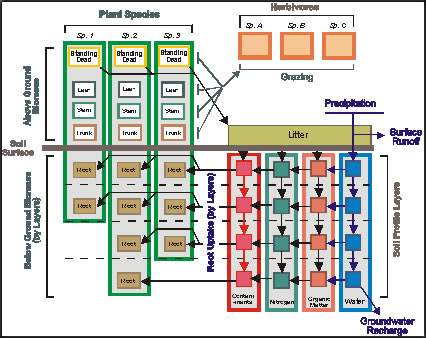 The EDYS (Ecological DYnamics Simulation) Model was designed to simulate the dynamics inherent in vegetation, in addition to natural and human-induced stressors. EDYS is a general ecosystem simulation model that is mechanistically-based and spatially-explicit. It simulates natural and anthropogenic-induced changes in hydrology, soils, plants, animals, and watershed components across landscapes, at spatial scales ranging from plots (square feet) to watersheds (square miles). It is dynamic, simulating changes on a daily basis, over periods ranging from months to centuries. EDYS has been used for ecological evaluations, watershed management, land management decision making, environmental planning, and restoration design analysis at 35 sites in 12 states and in Australia and Indonesia.
Cibolo Creek Watershed Background
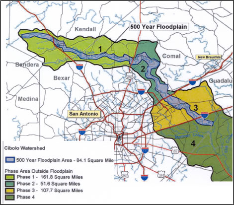
The Cibolo Creek watershed lies just north of San Antonio, TX, and covers approximately 165 square miles. The dominant native vegetation in the watershed is juniper-oak woodland, which is comprised of Ashe juniper (Juniperus ashei) and a variety of hardwoods, primarily live oak (Quercus virginiana). The area is experiencing increased urbanization as a result of its proximity to San Antonio, but also due to the scenic nature of the canyons in this portion of the Texas Hill Country. This area overlies several aquifers that are important water sources for San Antonio and surrounding communities. The watershed averages about 38” of rainfall annually, but is occasionally subjected to high intensity rainfall events. Due to increased urbanization, these high intensity rainfalls turn into severe floods, causing damage in the watershed and downstream. USACE – Fort Worth District entered into a study to evaluate both flood control issues and aquifer recharge, along with Guadalupe-Blanco River Authority (GBRA), San Antonio River Authority (SARA), and San Antonio Water Supply (SAWS) as sponsors, while also partnering with Natural Resources Conservation Service (NRCS), U.S. Geological Survey (USGS), U.S. Fish and Wildlife Service (USFWS), and Texas Parks and Wildlife Department (TPWD).
The EDYS Model Application at Cibolo Creek
 The EDYS Model was applied to the watershed at Cibolo Creek with the objective of investigating probable effects of land management practices (such as brush management, livestock grazing, urbanization, reseeding and restoration, and the location of detention structures) on recharge, surface runoff, and environmental restoration. EDYS was used to simulate likely outcomes of these management alternatives on ecological and hydrological variables. The model was validated by applying it to the nearby Honey Creek watershed, which is also dominated by juniper-oak woodland and contains many of the same soil profiles. Runoff and evapotranspiration (ET) data have been collected in this watershed in a collaborative study involving USGS and NRCS. The validation results indicated that EDYS was 89% accurate in simulating ET and runoff, an accuracy that was within the 80-90% maximum potential accuracy afforded by variation in the recorded rainfall data.
Linkage with HSPF
USGS modelers used HSPF (Hydrological Simulation Program – Fortran) in the Cibolo Creek watershed to evaluate a recharge/dry detention structure for its flood damage reduction and aquifer recharge benefits. HSPF is typically used to simulate watershed hydrology and water quality; however, its vegetation component assumes static conditions throughout the simulation. EDYS was linked to HSPF to provide improved input data relative to changes in vegetation and subsequent impacts on soil moisture. EDYS outputs used to calibrate HSPF included monthly totals for each land use for interception, soil moisture levels, soil depth, potential and actual evaporation, potential and actual transpiration, and Manning’s N as an estimate of surface roughness.
The dynamic outputs from EDYS allowed the USGS modelers to vary input data on a monthly basis, and in effect, simulate the impacts of vegetation dynamics on hydrological variables. The result is greater accuracy in the hydrological simulations, by taking into account vegetation changes from natural processes and anthropogenic disturbances.
Brush Management Optimization
Original analysis of brush management in the Cibolo Creek watershed suggested that maximum benefits to aquifer recharge and runoff would result from the treatment of 65,000 acres of juniper-oak woodlands. But, this amount of treatment was deemed too costly for the magnitude of the benefits. EDYS was used to evaluate a variety of brush management options in order to optimize the location and extent of area to treat. Some of the options included treatment based on soil types, density of woody vegetation, slope, treatment of mesquite and undesirable herbaceous species, seeding post-treatment, use of buffer strips around riparian areas, co-location with recharge structures, timing of re-treatments, location within the watershed, and extent of treatment.
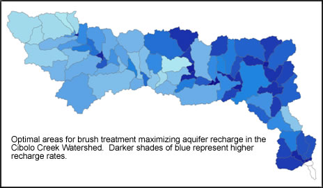 A variety of conclusions were drawn from the simulation results, some of which are summarized below. Treatment based on woody density was more important in determining recharge than treatment based on soil types. Treatment of mesquite and undesirable herbaceous species had little impact, largely due to the limited occurrence of them in the watershed. Seeding post-treatment had little impact on recharge, but helped to reduce runoff amounts. Buffer strips along riparian corridors reduced both recharge and runoff, but are considered ecologically desirable because they reduce soil erosion. Co-location of treatment with recharge structures benefited aquifer recharge, but not as much as assumed. Most importantly, the simulations showed the most beneficial locations in the watershed to concentrate treatments, but not the number of acres to treat. That decision was left to the project sponsors to make, based on a cost/benefit analysis using treatment costs and the “value” of increased aquifer recharge.
Using EDYS on Your Project
Since EDYS is a general ecosystem simulation model, it can be used in a variety of restoration planning efforts. It has particular relevance in watershed studies, but also in more localized settings. In other projects, EDYS has been used to evaluate revegetation and cover designs, land management decision impacts on a variety of ecological variables (such as runoff water quality and quantity, groundwater use by plants, forage for wildlife, invasive species, and community persistence and resilience), and habitat for sensitive, threatened, and endangered species. Additionally, EDYS has been used for NEPA compliance and has been shown to be effective at integrating inputs from multiple stakeholders.
For more information, please contact Cade Coldren at cade.l.coldren@us.army.mil, David Price at david.l.price@usace.army.mil, or Terry McLendon at terrymclendon@comcast.net and at www.ks2efs.com.
Additional Resources
EBA Resources
