|
|||
| Home | About EBA | Technical Documents | Tools | Case Studies | Contact Us |
|
||||||||||||||||
Modeling Freshwater Flow Diversions for Coastal Restoration: An Example from Coastal Louisiana
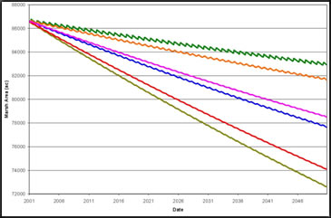
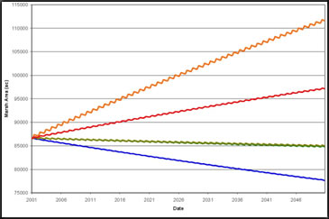
In response to the catastrophic events of Hurricanes Katrina and Rita, the U.S. Congress directed the U.S. Army Corps of Engineers to “conduct a comprehensive hurricane protection analysis and design…to develop and present a full range of flood control, coastal restoration, and hurricane protection measures” (i.e., Louisiana Coastal Protection and Restoration, LACPR). This resulted in interagency efforts to assess and weigh benefits of coastal restoration via freshwater flow diversion. What are freshwater flow diversions? Although flow diversions provide a tool for combating coastal land loss, the optimization of flow diversion locations and operation has been difficult due to the complexity of data needs for a coupled ecological and hydrodynamic model. These complexities encouraged the development of a simple, screening-level model that includes the effects of vegetation growth and senescence as well as sediment dynamics. This would allow for straightforward examination and optimization of flow diversion feasibility and operational benefits. Model Selection & Adaptation Components of the Model Sediment Inputs – combine the concentration of sediment from source water (typically the Mississippi River) with known diversion rates to determine the amount of diverted sediment. (The modification incorporated daily variation of both diversion and river discharges and increased the temporal resolution to examine diversion structure operation.) Sediment Retention – identify the fraction of diverted sediments retained within the coastal wetland as a function of wetland geometry, sediment size and flocculation rates, and flow hydrodynamics. Verification and Application: Caernarvon Diversion and Breton Sound Estuary Figure 2 presents the evolution of land area within Upper Breton Sound from before the diversion was opened (1 November 1990) until the end of 2006 (31 December 2006). The estimated future without project (FWOP) is presented to provide the magnitude of marsh area benefit the Caernarvon Diversion is providing Breton Sound. Vertical lines indicate the beginning of diversion operation and hurricanes making landfall in Louisiana. It is clear that hurricanes create significant disturbances to the system; however, for the purpose of this screening level model, hurricanes are assumed to create no net import or export of sediment over a long planning horizon. 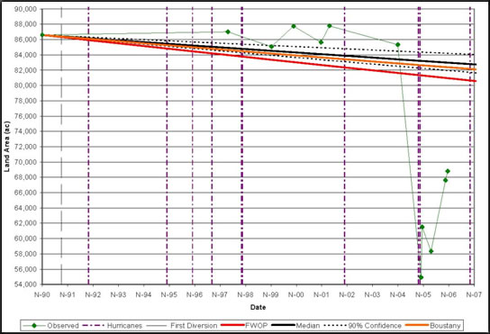 Figure 2. Marsh area prediction for the Caernarvon Diversion from 1990-2006 with observed acreages, model predictions with parameter uncertainty bounds, as well as the Boustany Model predictions Diversion Optimization
Limits and Future Application With these limitations in mind, SANDv1.0 served as an appropriate screening tool to screen the number and location of diversion sites for LACPR. The modifications to the model were crucial for examining different operational and structural scenarios and alternatives. EBA Resources |
||||||||||||||||
|
Updated: July 2024 |
||||||||||||||||
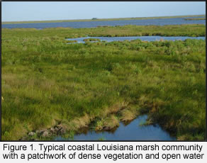 Fresh water flow diversions release river water into marshes to simulate flooding of a river onto its floodplain and thus increase hydrologic connectivity. Freshwater flow diversions offer significant nutrient and sediment inputs to marshes that promote both organic and inorganic accumulation of soil.