Throughout much of the newly independent United States, the GLO surveyors recorded information on hydrography and terrain, as well as specific data on vegetation composition and structure. When these notes and measurements are transferred to a Geographic Information System (GIS) and overlain on modern maps and aerial photographs, the information they contain can provide insight into both natural and man-made changes that have occurred to the physical and biological environment of a region. This historic information can aid ecologists in establishing a reference condition for a study area and help to define opportunities for ecosystem restoration.
What are General Land Office Surveys?
 The GLO surveys were initiated in 1785 to provide a basis for dividing and selling public lands within the newly established United States. Teams of surveyors were dispatched to various parts of the country to establish township, range, and section boundary lines. The basic survey unit was the six-mile-square township and was subdivided into 36 one-square-mile sections and again into quarter sections.
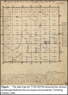
As the surveyors measured the section boundaries they made detailed handwritten notes on of the environmental features and landmarks they encountered and recorded their locations. The most detailed data in the survey notes concerned forest composition and structure, including measurements of individual trees. Based on these surveys and extrapolations between survey points, plat maps were created that depicted the approximate size and location of all water bodies in each township.
The GLO surveys were initiated in 1785 to provide a basis for dividing and selling public lands within the newly established United States. Teams of surveyors were dispatched to various parts of the country to establish township, range, and section boundary lines. The basic survey unit was the six-mile-square township and was subdivided into 36 one-square-mile sections and again into quarter sections.
As the surveyors measured the section boundaries they made detailed handwritten notes on of the environmental features and landmarks they encountered and recorded their locations. The most detailed data in the survey notes concerned forest composition and structure, including measurements of individual trees. Based on these surveys and extrapolations between survey points, plat maps were created that depicted the approximate size and location of all water bodies in each township.
Grassy Lake Background
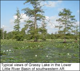
The Lower Little River Bottoms ecosystem is a complex of approximately 15,000 acres of lowland hardwood forest and an extensive bald cypress swamp known as Grassy Lake in Southwest Arkansas. It is one of the largest contiguous tracts of diverse bottomland forest remaining in the Gulf Coastal Plain Region of the United States and is particularly well known for waterfowl hunting. Private landowners have protected it for hunting purposes from the intensive forestry and agricultural activities that have altered the surrounding landscape.
The Degradation
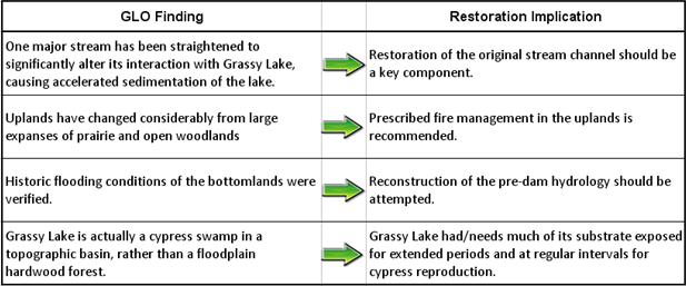
 The dynamic flood patterns that influenced Grassy Lake were dramatically changed in the mid-20th century when Millwood Dam was built for flood control in the Little River drainage basin. This construction disconnected the floodplain from the Little River in all but extreme flood events. At about the same time, private landowners began modifing the adjacent uplands, changing the pattern of local runoff and increasing sediment inputs to the system. Although natural flooding was hindered, the lands within the Lower Little River Bottoms were modified using levees, pumps, and drainage structures so that water could be detained or diverted into the lowland forests and Grassy Lake and managed for waterfowl hunting and fishing. After more than a half century, the effects of these man-made changes are evident in degraded hardwood stands, aquatic weed problems, and lack of cypress reproduction.
GLO Application
An essential part of the restoration plan was to identify the historical, pre-dam conditions of three major ecosystem components: hydrology, geomorphology, and the distribution of native plant communities. The GLO description data were used to reconstruct pre-settlement conditions, allowing recognition of the fundamental changes in ecosystem structure and processes that had occurred. They also helped determine the extent to which those changes are reversible, and if not, what alternative conditions can be established and maintained.
Findings
The GLO surveyors reported few signs of human activity within the wilderness of the Lower Little River Bottoms because the region was only sparsely settled when the GLO survey was conducted. Therefore, the survey notes represent a reasonable approximation of the undisturbed (pre-settlement) reference condition for the ecosystem. The GLO survey observations form a grid across the study area, providing information at regular intervals.
 Additional observations:
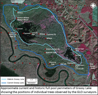
- Little or no change in bottomland tree species composition occurred since the early 1800’s.
- Enough permanent water was present in deeper areas that the GLO surveyors referred to it as a lake (although certain areas were intermittent, see table).
- The estimated historic lake contour does in fact represent the natural full-pool elevation of Grassy Lake (see picture).
Importantly, analysis of these data showed that the hydrologic patterns commonly seen in cypress swamps likely also occurred in Grassy Lake–generally shallow water conditions, but with regular substrate exposure during dry periods, sometimes extending for multiple years, allowing regeneration of the cypress forest as well as establishment of other, less water-tolerant, species. There also were times when flooding continued throughout the growing season and for multiple years, sufficient to kill the less tolerant species. The ecosystem restoration plan derived from these observations calls for a much more dynamic water fluctuation pattern than the one that has been employed since the lake level was raised in the mid-20th century.
 Using GLO Survey Data on Your Project
The GLO survey data can be used for more detailed vegetation analyses than were needed at Grassy Lake. In many instances, ecosystem restoration requires reforestation of large tracts of land that have been converted to agriculture, and the GLO tree data can be used to determine the appropriate species composition for various restoration sites, and can provide a template for reforestation over large areas. This method also can be used to detect major changes that have occurred within existing forests due to timber harvest, fire exclusion, flood control, and other influences.
GLO surveys were conducted in 30 states. Information about the General Land Office surveys, as well as many of the survey notes and plat maps can be obtained from the Bureau of Land Management http://www.glorecords.blm.gov/. In searching for information about the General Land Office surveys, it is important to note that these surveys are also often referred to as the Public Land Survey System (PLSS).
Additional Resources
EBA Resources
